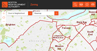
Boston Redevelopment Authority’s GIS Department debuts new Zoning Viewer
Oct 10, 2014
 The Zoning Viewer is a web application and mapping tool that provides assessing and zoning information for parcels throughout the City of Boston. The public facing web application is designed to assist city staff and the public in locating and determining zoning information for parcels of land in Boston.
The interactive viewing tool provides basic parcel information (address and owner) as well as zoning district, sub district, and applicable overlay districts. By selecting a parcel or typing in an address, one can discover City of Boston zoning and assessing information using the drop down menu. Users can turn on zoning districts and overlays with the layers feature (on the top right navigation bar) to see customized information displayed on the map.
For the first time, the Zoning Viewer is also optimized for use on mobile devices.
This application greatly simplifies our ability to get at critical zoning information combined with other GIS data,” said Carolyn Bennett, the BRA’s Geographic Information Systems (GIS) Manager. Staff and the public now have current information at their finger tips to make more informed planning decisions.
The web application was written using Esri ArcGIS API for JavaScript and ArcGIS server technology. Blue Raster, a mapping solutions company, consulted with the BRA to deliver the new Zoning Viewer.
Zoning disclaimer: The Code Maps, enacted by the Boston Zoning Commission and available on the BRA’s website, together with any amendments, remain the official zoning documents. The information reported on the Zoning Viewer may not reflect the most current regulations adopted by the Boston Zoning Commission. If discrepancies exist, the official signed Code Maps shall be considered correct. For more information on the zoning code, click here.